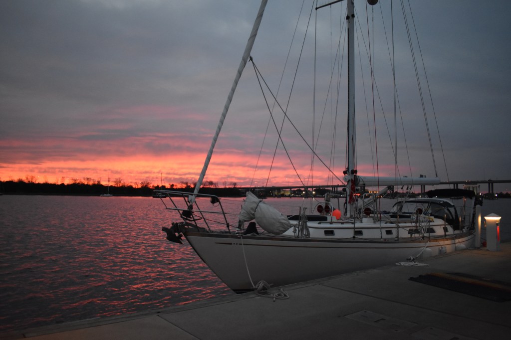
This year we decided to move Andante south to North Carolina for winter storage. Despite the distance from home, the warmer climate and DIY boatyard offers more opportunity to get off-season jobs done ourselves. In addition, the trip south gives us one last chance for adventure this season, with memories that can hold us until we return to the water next spring. While Dave has logged thousands of miles aboard Andante, this would be my first extended trip with overnight watches and more solo responsibility while underway – exciting and scary! We spent our final night before departure aboard the boat dockside, eating take-out from our local Chinese restaurant. The message in my fortune cookie seemed particularly fitting – “Take the chance while you still have the choice.”
We departed Red Brook Harbor under very cold and cloudy skies, riding a north wind southwest through Buzzards Bay. The forecast predicted that the winds would steadily drop to almost nothing by mid-day, shifting to the northeast and building some overnight. Based on this our plan was to follow the coast along the seaward side of Long Island, heading offshore to cut the corner and dodge traffic inbound to New York Harbor, ultimately arriving in Cape May, New Jersey. But forecasts are not always accurate, and plans must then change!
The day started smoothly, with a gorgeous sail out of Buzzards Bay and views of the new windfarm being constructed offshore of Martha’s Vineyard. The night to follow was very different than expected, with winds shifting southeast and building continuously throughout the night. A large quartering sea made it very difficult to keep the sails full and happy and hence Andante happily rolled from rail to rail. The sole log entry made by Dave between 0130 and 0930 simply says “stuff happened” — it was a bit too rough to write. In the early hours before dawn we made the decision to change our plans and head toward shore. After another full day of slogging through confused seas and heavy winds, we anchored exhausted in Atlantic Highlands, NJ with winds gusting to 40 kts after 33 hours underway. Before heading to bed, I opened the last fortune cookie left from our dinner the night before. The message said “The first attempt is the most difficult.”
Dockside ready to go!
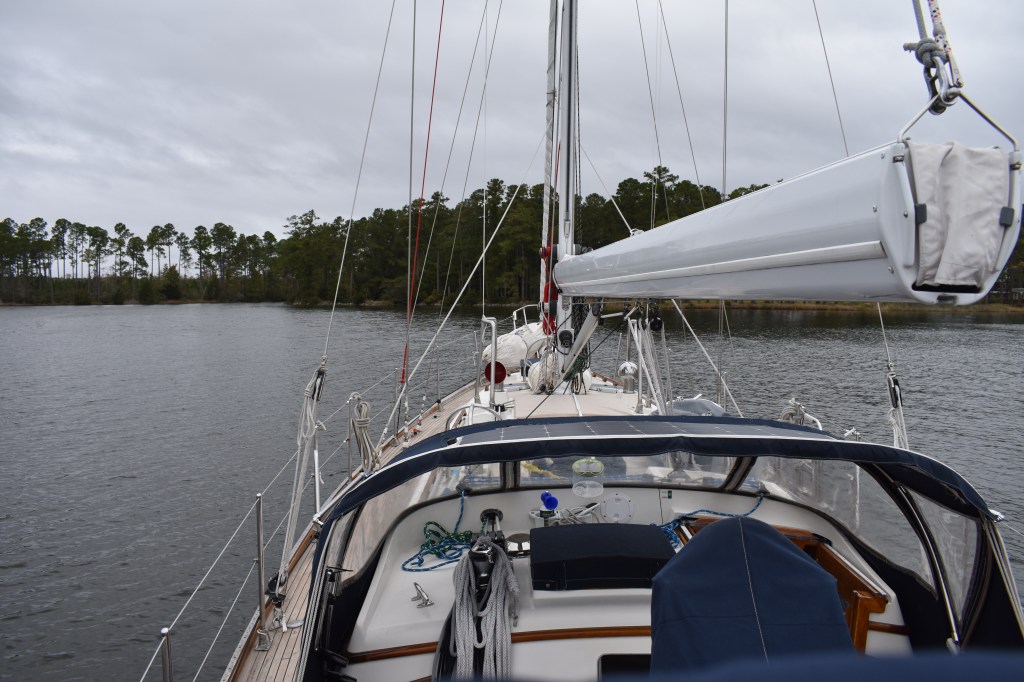
All bundled up but the bow is pointed in the right direction
Don’t ask how many layers are under that lifejacket!
So where is the old Providence? Let’s ask The Google:
“The name New Providence Island is derived from a 16th‐century governor who gave thanks to Divine Providence for his survival after a shipwreck. The “New” was added later to distinguish it from Providencia in Western Caribbean (now Colombia) used by pirates.” Thanks Google.
Almost 75% of the Bahamian population lives on this one island — and there are hundreds of islands and thousands of small cays (always pronounced “keys” hereabouts) in the country. Temporarily add one person (and one boat): Andante and I arrived in West Bay, New Providence this afternoon after a nice sail from the Berry Islands.
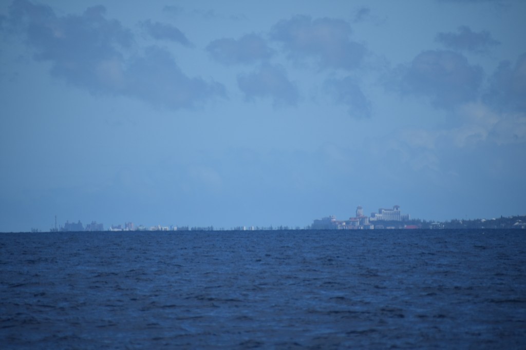
Very-long-range view of the hotels and casinos and whatnot in Nassau Harbor and Paradise Island. We are on the opposite end of the island.
West Bay is surrounded by a park, a golf course and the exclusive community of Lyford Cay. And a noisy and smelly power plant. But its still a pretty nice spot to spend a day or two and wait for northerly winds to head further south to the Exumas. Some folks have written about excessive surge and uncomfortable rolling at anchor here but with a 15 kt southeast wind we’re barely moving at all.
Andante in West Bay, New Providence.Same, but from a lower viewpoint. The water is clear enough that you can see the anchor chain on the bottom. But it is a bit greener than in the Berrys. I don’t know exactly why but imagine nutrient-rich runoff from the surrounding manicured community and golf course may contribute.
The first thing I did after anchoring was jump overboard. The water temperature was finally above 70 (yay) and I’d read accounts of poor holding (uh oh). So I dove in and gave the anchor a check to make sure it was set well.
The anchor. You can see that it did drag a bit before setting. I placed two sand dollars just behind it as a reference and will check in the morning to see if it moved any further. Between the 55 lb anchor and the boat are 125 feet of 3/8″ chain (about 175 lbs). All this chain generally prevents the anchor from being pulled upwards and dislodged. The trip line is connected to a surface float to mark the anchor position and so I can extract the anchor backwards should it get wedged under a rock.
While I was in the water I gave Andante an all-over bottom inspection. She looked good except that the prop zinc (the bit that I inspected in very cold water due to a mysterious vibration way back in Fisher Island, NY) was completely consumed. It didn’t fall off but rather completely corroded off. In less than 60 days. Hmm. Not sure why yet but went ahead and replaced it while I was wet. Will watch it carefully over the next few weeks. Hoping it has to do with the dockside 120V electrical system in Beaufort and not the 12V system onboard.
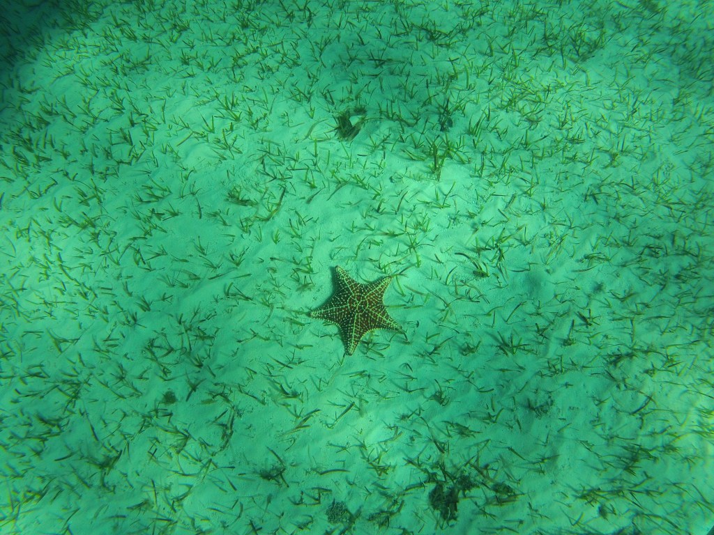
The prop is a little discolored but had no growth on it. I replaced the missing anode (grey lump on aft end of the hub) with a new one.Just in case you wondered what a 2 m boat looks like in 3 m of water. This was taken at close to 1/2 tide so we may be another 20-30 cm closer to the seabed at low tide. The bottom is mostly sand with some grass. Actually more (and greener) grass than portions of my yard.I do not have giant starfish in my yard. But otherwise the ground looks similar. This fellow was about 8″ across and directly under the keel.
It rained last night in the Berrys – at 0230. I know this because my porthole was open and I got splashed in the face. This evening just before sunset it was obvious that a squall was coming our way so I closed everything up tight in advance.
Squall at sunset.
The rain was hard and lasted more than an hour. But no complaints: Andante was covered in salt from today’s sail and always enjoys a good shower. I just wish it would rain soap briefly before the rinse cycle.
When I have a chance (and can find some fabric) I’d like to make some rain flys for at least one or two of Andante’s hatches so they can remain open in all weather. It gets a bit stuffy below with all the hatches and ports closed.
Anyway, the plan for now is to hang out here tomorrow and do boat jobs. Perhaps I’ll do a little more swimming and give Andante’s waterline a good scrub. Then on Thursday we’ll ride the north wind down to Highbourne Cay in the northern Exumas.
Bonus Content!
I didn’t have the bandwidth until today to upload these recent videos. Enjoy.
The other day as we were leaving Bimini a group of dolphins led me out of the harbor. One of them played on the bow for several minutes. Good fun.
And while dockside in Bimini I watched some fisherman throw scraps to a big group of nurse sharks. Pretty spectacular. I was actually more afraid of the greedy pelicans.
Andante and I are still hanging out in Fort Pierce Inlet waiting for a weather window to head south and cross to the Bahamas. The latest forecasts suggest the next opportunity may be Sunday or Monday so I’m starting to get organized. Groceries, fuel, water, then Covid test, then go. Or not, depending on the actual weather that materializes. Good thing Fort Pierce is a nice (and relatively inexpensive) place to wait.
Like many of the boats around here waiting to cross I’m using the daily summaries and interpretations from Chris Parker for weather guidance in addition to my own analysis. I really like how his team understands that sailors are not looking for optimistic forecasts. I’d much rather plan around the worst likely scenario than hope for the best. Andante can handle some pretty nasty conditions without complaining. Not me.
Mmm fruits. The avocados are from Mexico and I’m not certain the limes are local. But the honeybells (a cross between a tangerine and a grapefruit) are definitely Indian River local and only available in January. They are really yummy.
Earlier this week I had a chance to visit the long-running and well-organized Fort Pierce Farmers Market. Lots of vendors selling foods and art and jewelry and whatnot. The actual local farm goods were less evident than I had hoped but I did pick up some fruits and some local shrimp. The honeybells, in particular, were fantastic. Almost ridiculously sweet and juicy and only available in January. Lucky me.
The farmers market is conveniently held in a park right next to the city marina where I can safely tie up Dinghy. It was a cool and slightly misty morning but not as cold as it looks.There were booths selling just about everything. Including some pretty weird stuff with curious marketing choices. Note the “Not made from iguanas” disclaimer. Yay?Downtown Fort Pierce is kind of cute. Lots of little shops and restaurants.Alcohol and axe throwing. What could go wrong?
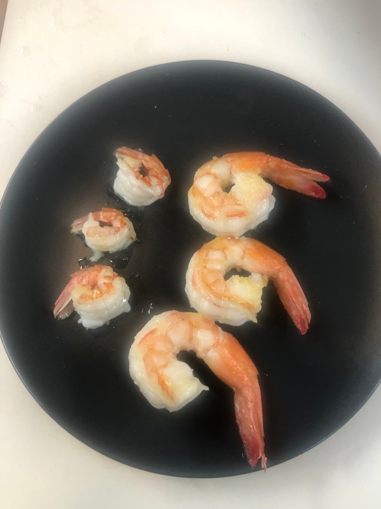
I also purchased some local shrimps from the farmers market. This booth had one of the longer lines at the market and there were folks in front of me ordering hundreds of dollars in shrimp. I settled for a pound each of two varieties. I did a quick taste test that afternoon and then a few nights later made a really yummy risotto with a stock based on toasted shrimp heads.
The large brown shrimp (top) and rock shrimp (bottom) were sold green and frozen in one-pound ziplocks from a big cooler. Once defrosted the soft-shelled browns cleaned up very easily. The rock shrimp were well armored and it was hard work getting the shells off.I sauteed a sampling of each very simply in olive oil and salt. Yum. The little rock shrimp were bright and lobstery while the big browns were the most shrimpy shrimp I’ve tasted. Very full and complex flavor. I enjoyed them both but would probably pass on the rock shrimp next time unless somebody else peeled them for me.
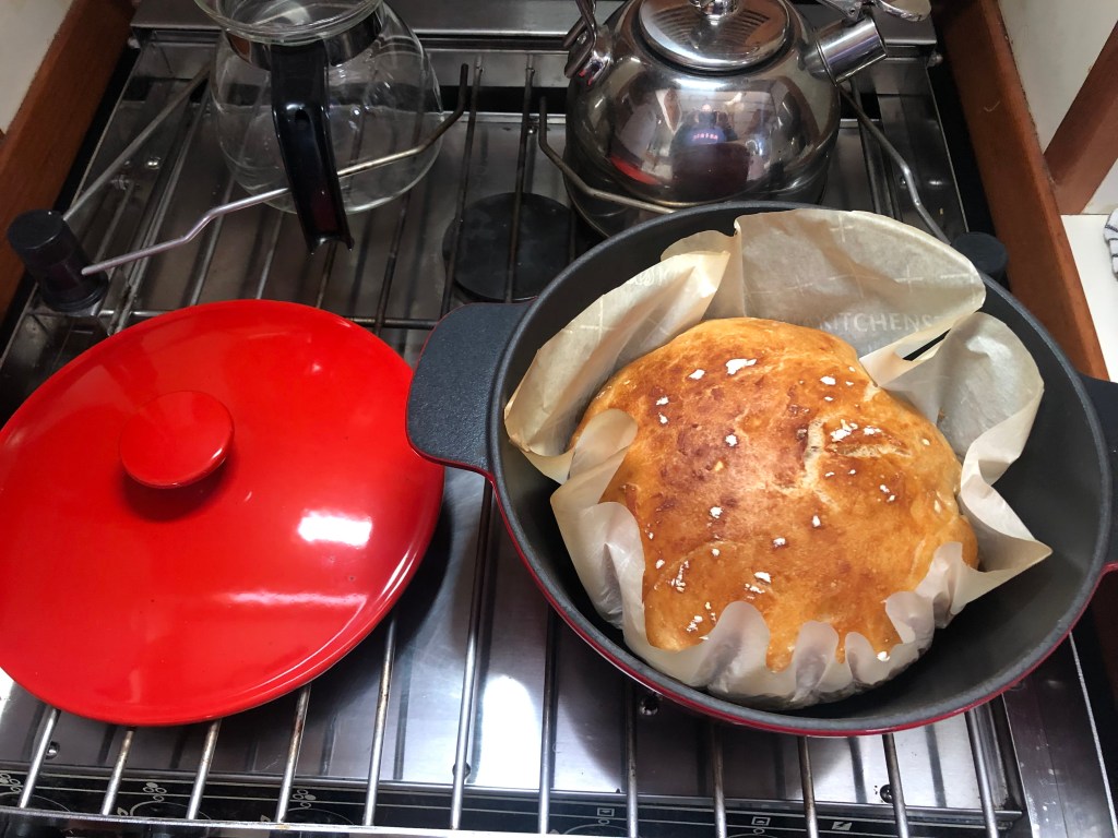
Since we’re on the subject of food I will mention that my bread baking, by necessity, is improving. I’m now making a loaf about every third day. I’ll share my recipe in a future post. Everyone is making no-knead bread. I’m trying to perfect no-mess bread since cleaning up splattered flour and sticky dough is a PIA (and water-waster) on the boat.
Mmm bread.Breakfast: Boat toast (bread fried in butter until crispy) and avocados with lemon.
The waiting is tough since I’d much rather be sailing. But I’m using the time as best I can to catch up on engine maintenance (oil changes, etc.) and some ongoing deck and rigging projects. I’ve been shuttling fuel and water from a nearby marina so that all the tanks are in a near-constant state of fullness just in case there is an opportunity to leave. The required Covid test complicates matters somewhat but with a weather window of reasonable duration shouldn’t be a show-stopper.
Our trip down the long and winding ICW from Beaufort has not been unpleasant. But it was definitely a pleasure to get out into deeper water and really sail for the first time in several months. After an enjoyable two nights dockside in Charleston (and many long walks around the city) we took advantage of a brief weather window to run offshore South Carolina and Georgia to the St Mary’s River inlet and Fernandina Beach, Florida. There was great sailing weather for the first third of the 28 hour trip. We covered many miles on a three-sail broad reach about 5 miles offshore before the wind got fickle and died. That left us with an overnight motor in glassy seas under a nearly-full moon. Not unpleasant at all.
At the entrance to the St. Mary’s River we were greeted by the guns of Fort Clinch. Andante was not intimidated. We were a bit taken aback by the industrial waterfront of Fernandina Beach and the odors of the pulp mill but we found a nice secure mooring to hold us through the gale that arrived overnight. My instruments recorded a max wind of 52 knots. Wheee!
Its still blowing 35-40 kts as I write this –so expect to stay put until at least tomorrow to allow the wind and seas to moderate a bit. The goal is always to sail the boat so wind is good — but wind direction and sea state matter a great deal. As we head south along the east coast of Florida the ideal weather is something like 15-20 kts from the west. These conditions would allow us to sail at full speed a few miles offshore where the wind is strong but locally-generated waves are fetch-limited. We might still see swell from distant storms but even large swell is more comfortable than short steep waves. These are the general conditions expected beginning late Monday through Tuesday and into Wednesday. I hope to take full advantage of them. The near-term plan is to push south to Port Canaveral and possibly further (Ft. Pierce? West Palm?) as the weather allows.
We should be in South Florida (somewhere between West Palm Beach and Miami) by the end of next week. Once there I’ll take some time to decide whether to head further south to the Florida Keys or make the short hop (around 60 nm) to the Bahamas. Either way, things are definitely looking warmer and sunnier. Yay!
Later today I’ll work on updating the “Trip” link, above, to provide a summary of the 2022 trip legs.
Dockside in Charleston the night before departure.Red sky at night, sailors delight. Or, if you prefer, from Matthew 16:2-3: He answered and said to them, “When it is evening you say, ‘It will be fair weather, for the sky is red’; and in the morning, ‘It will be foul weather today, for the sky is red and threatening.’ Regardless, the sky was extremely red the night before we left Charleston suggesting a pleasant day ahead. We had some traffic on our way out of Charleston harbor. The entrance channel is fairly narrow and with ships and tugs moving in both directions we chose to run just outside the channel between the green buoys and the jetty. I spoke with both the tug and the container ship to let them know our intentions.Finally making some progress under sail. This was just after turning off the engine outside of Charleston with winds 10-15 from the NW. Almost perfect.Sunset at the end of the first day out. Wind has now died to less than 5 kts and shifted to the south — no more sailing for now. Serious chemtrail action around here.Sunrise on glassy seas the next morning. The entire trip crossed an important right whale conservation area and had hoped this would be a good whale watching day. I did see lots of dolphins and birds and a lone sea turtle but no large whales. A little later that morning we saw a nice example of a mackerel sky. These high puffy clouds (cirrocumulus) look like fish scales and indicate that a change is coming. “Mackerel sky, not twenty-four hours dry” is the saying. (Source unknown, but not Jesus). Another correct prediction – by late evening we were being walloped with strong wind and heavy rain. Fort Clinch on Amelia Island at the mouth of the St. Mary’s River. Lots of beachgoers and kayakers on a warm Saturday morning. The opposite side of the river is Cumberland Island, Georgia. I’m pretty sure we strayed across the centerline so we’ve now passed through all 12 states between Massachusetts and Florida.Heading south on the Amelia River. I’m guessing this is a pulp mill but can’t get past how the big pile reminds me of the mashed potato mountain in Close Encounters. Also tough to get past the smell. Fortunately we’re upwind today.The view from our mooring in Fernandina Beach before the wind started blowing. The view in the other direction. Given today’s winds I don’t expect to put Dinghy in the water and explore the town. Instead I’m using the time to catch up on some cleaning and maintenance. And baking some bread — because I actually need bread and not just as an excuse to heat the cabin.
Yesterday we completed a relatively short hop from Belhaven to Broad Creek on the Neuse River. Along the way we passed the first (but certainly not the last) shrimp boat of the trip and a small Coast Guard station near the Hobucken Bridge.
Shrimp boat at R.E. Mayo SeafoodUSCG Station Hobucken
After getting tossed around a bit in Pamlico Sound and the Neuse River we pushed as far up Broad Creek as our draft would allow and found a snug spot close to shore to wait out another gale.
Anchored close to shore. Decks cleared and everything tied down. Wood smoke and owls. Better in here than out there.
The winds and rain should start any time now and persist through tomorrow. Hopefully by Monday morning nice weather will return and we’ll set off towards Beaufort, NC and the final destination of this leg of our trip: Bock Marine. With 25 nm to go we should arrive at the yard shortly after lunch.
While waiting for the storm I’ve made some changes to the other pages on this site. Comments and suggestions for further improvement are welcome.